Global warming has melted a large number of ice in the arctic and Antarctic. Last news said that as the effect of global warming, hundreds of Antarctic icebergs are floating towards New Zealand in a rare event which has prompted a shipping warning.
An Australian Antarctic Division glaciologist said the ice chunks, spotted by satellite photography, had passed the Auckland Islands and was heading towards the main South Island, about 450 kilometers or about 280 miles northeast.
Scientist Neal Young told AFP that more than 100 icebergs, some measuring more than 200 meters (650 feet) across, were seen in just one cluster, indicating there could be hundreds more. They were the remains of a massive ice floe which split from the Antarctic as sea and air temperatures rise due to global warming.
All of the icebergs have come from a larger one that was probably 30 square kilometers (11.6 square miles) in size when it left Antarctica
The icebergs make a long circuit around Antarctica and the bigger parts of it are breaking up and producing smaller ones. Large numbers of icebergs never floated close to New Zealand since 2006. The first sighting was in 1931 when a number came within 25 kilometers of the coastline.
New Zealand has already issued coastal navigation warnings for the area in the Southern Ocean where the icebergs have been seen. Maritime New Zealand spokesman Ross Henderson say that It is a general warning for shipping in that area to be on the alert for icebergs.
The icebergs are smaller remnants of the giant chunks seen off Australia's Macquarie Island this month, including one estimated at two kilometers (1.2 miles) and another twice the size of Beijing's "Bird's Nest" Olympic Stadium.
More and more icebergs will seen in the area if the Earth's temperature continues to increase and the current trends in global warming were continue.
When icebergs last neared New Zealand in 2006, a sheep was taken by helicopter out to be shorn on one of the floes in publicity stunt by the country's wool industry.
If we let this continued without do something soon we will loose numbers of islands, as the impact of sea level rising. Even a small reduce of the carbon emition could help us to see that islands for longer time.
Showing posts with label global warming. Show all posts
Showing posts with label global warming. Show all posts
November 24, 2009


Antarctic ice has melted!
So far, global warming has been known to melt ice in the polar north. Actually, Global warming also make a similar result to the layer of ice in the Antarctic. If this continues, we might soon lose the land where we stand today.
Results of recent studies published in Nature Geoscience mention that ice sheets in East Antarctica, once seen mostly unaffected by global warming, has lost billions of tons of ice since 2006 and could push sea water level rise in the future.
The study also shows that the smaller but less stable ice in the West Antarctic mass loss in a very large number. Global warming is also feared could spark rapid division of West Antarctica, melt the ice that will pushing the global ocean surface as high as five meters.
In 2007, the Intergovernmental Panel for the UN climate change (IPCC) predicts sea levels will rise 18 to 59 centimeters in 2100 at the latest, by not entering the impact of ice began to crack in Greenland and Antarctica. Greater impact would have happened if they were taken into account.
Many scientists say that even if the emission of CO2, one of the causes of global warming is limited, the surface of the ocean water may be increased by about three feet. This is enough to make some small island countries and could also damage the habitable and fertile delta of the habitat of hundreds of millions of living beings.
More than 190 countries will gather in Copenhagen, in December, to design a climate change agreement to curb greenhouse gases and help poor countries cope with the consequences
Results of recent studies published in Nature Geoscience mention that ice sheets in East Antarctica, once seen mostly unaffected by global warming, has lost billions of tons of ice since 2006 and could push sea water level rise in the future.
The study also shows that the smaller but less stable ice in the West Antarctic mass loss in a very large number. Global warming is also feared could spark rapid division of West Antarctica, melt the ice that will pushing the global ocean surface as high as five meters.
In 2007, the Intergovernmental Panel for the UN climate change (IPCC) predicts sea levels will rise 18 to 59 centimeters in 2100 at the latest, by not entering the impact of ice began to crack in Greenland and Antarctica. Greater impact would have happened if they were taken into account.
Many scientists say that even if the emission of CO2, one of the causes of global warming is limited, the surface of the ocean water may be increased by about three feet. This is enough to make some small island countries and could also damage the habitable and fertile delta of the habitat of hundreds of millions of living beings.
More than 190 countries will gather in Copenhagen, in December, to design a climate change agreement to curb greenhouse gases and help poor countries cope with the consequences
November 10, 2009
Will we loose the islands?
Global Warming is one of the most talked issues of the 21st century. We know that, the pollution is increasing even in a larger ratio when the world population is increase. Many countries should implemented “Green” policies, to protect the environment and future of the earth. These policies are increasingly being implemented in Central Europe in countries such as Germany. Recycling garbage, plastic, and even old appliances belongs to the strict regimen. Other policies such as fines imposed on littering, burning of waste or leaves, and even the encouragement of collective transportation have been imposed.
In the Philippines a Waste Management Act has been implemented. But some say that in our everyday lives; the sad reality comes crushing down on Filipinos that barely care for the environment. People burning their garbage in their home and on the streets, shower with the abundance of fresh water. All of these plays a big role as a contributor in global warming.
Let us see and analyze the facts about what caused of global warming. Many people believe (which is also true) that so called greenhouse gases that emit CO into the atmosphere which causes the rays of the sun to be kept within the earth atmosphere for a longer time, since it bounces back. This causes an increase of temperature, which in turn causes more natural catastrophes. Although this is the main cause of global warming, there is yet another cause, which has something to do with the cycle of our Sun. Every ten to twelve years, the sun is in its peak and vice versa. The peak is the solar maximum, which means that this is when the sun is the hottest and emits more solar storms than ever. This period should be the solar maximum of the sun, since the last was in the 90s. This is also an important factor that contributes to global warming.
Some people think that global warming does not really affected their life. Let’s see it again. Because of global warming Dengue fever is spreading much farther and faster around the country due to increased humidity. Global warming make the shores will soon move closer by a meter or more each year as impact of the icecaps melting. Global warming caused more and more floods on the islands and surrounding regions. Global warming make people hunger because their crops were destroyed in natural disasters such as storms, floods, or heat/dryness. Global warming threatens to submerge parts of Manila, Philippine and wipe out the entire islands. Global warming caused the increased of sea level, we will lose islands because of it.
In the Philippines a Waste Management Act has been implemented. But some say that in our everyday lives; the sad reality comes crushing down on Filipinos that barely care for the environment. People burning their garbage in their home and on the streets, shower with the abundance of fresh water. All of these plays a big role as a contributor in global warming.
Let us see and analyze the facts about what caused of global warming. Many people believe (which is also true) that so called greenhouse gases that emit CO into the atmosphere which causes the rays of the sun to be kept within the earth atmosphere for a longer time, since it bounces back. This causes an increase of temperature, which in turn causes more natural catastrophes. Although this is the main cause of global warming, there is yet another cause, which has something to do with the cycle of our Sun. Every ten to twelve years, the sun is in its peak and vice versa. The peak is the solar maximum, which means that this is when the sun is the hottest and emits more solar storms than ever. This period should be the solar maximum of the sun, since the last was in the 90s. This is also an important factor that contributes to global warming.
Some people think that global warming does not really affected their life. Let’s see it again. Because of global warming Dengue fever is spreading much farther and faster around the country due to increased humidity. Global warming make the shores will soon move closer by a meter or more each year as impact of the icecaps melting. Global warming caused more and more floods on the islands and surrounding regions. Global warming make people hunger because their crops were destroyed in natural disasters such as storms, floods, or heat/dryness. Global warming threatens to submerge parts of Manila, Philippine and wipe out the entire islands. Global warming caused the increased of sea level, we will lose islands because of it.
October 25, 2009
The impact of global warming in Indonesia

Global warming (global warming) is essentially a phenomenon of global temperature increases from year to year because of the greenhouse effect (greenhouse effect) caused by increased emissions of gases like carbon dioxide (CO2), methane (CH4), nitrite dioxide (N2O) and CFCs so that solar energy trapped in the earth's atmosphere. See "what caused global warming?". The literature shows an increase in global temperatures - including
Global warming impact caused extensive and serious for the bio-geophysical environment (such as melting polar ice caps, sea level rise, expanding deserts, increasing rainfall and floods, climate change, extinction of certain flora and fauna, the migration of fauna and pest and disease, etc. ). While the impact on the socio-economic activities of the community include: (a) disruption of the function of coastal areas and coastal cities, (b) disruption of the function of infrastructure and facilities such as road networks, ports and airports (c) disruption of residential areas, (d) reduction productivity of agricultural land, (e) increased risk of cancer and disease, etc.)
The impact of rising sea levels and flooding on Bio-geophysical Environment and Social-Economic Condition.
Sea level rise would result in general the following impact: (a) increased frequency and intensity of floods, (b) changes in ocean currents and the widespread destruction of mangrove, (c) expansion of sea water intrusion, (d) a threat to the socio-economic activities of society coastal, and (e) reduction in land area or loss of small islands.
The increased frequency and intensity of floods caused by the random pattern of rainfall and short rainy season while the very high rainfall (extreme events). Another possibility is due to backwater effects from coastal to inland areas. The frequency and intensity of flooding is predicted occurs 9 times greater in the next decade where the 80% increase in flooding occurred in South and Southeast Asia (including
• sea-level rise than the ocean currents cause changes in the coastal areas also cause damage to the mangrove ecosystem, which currently only condition is very worrying. Extensive mangrove forests in
• The spread of sea water intrusion caused by the occurrence of other than sea level rise was also triggered by the occurrence of land and excessive ground water exploitation. For example, estimated in the period between 2050 until 2070, then the sea water intrusion will cover 50% of the total area of
• disruption of socio-economic conditions of society that occurred among others: (a) the disruption of road networks and railway traffic in Pantura, East Java and South Sumatra; (b) a pool of settlements in the coastal cities located in areas Pantura Java, Sumatra, eastern, southern Kalimantan, south west Sulawesi, and some coastal spots in Papua; (c) loss of cultivated land such as rice fields, brackish fish ponds, and mangrove area of 3.4 million hectares, equivalent to U.S. $ 11.307 million; this picture becomes even more 'blurred' when linked to the existence of centers of food production is only range from only 4% of the total national area, and (d) decrease in land productivity in food centers, such as the Citarum river , Brantas, and Saddang very crucial for the survival of food self-sufficiency in Indonesia. The areas of
• Risk reduction in coastal area and even the loss of small islands that can reach 2000 to 4000 the number of islands, depending on sea level rise that occurred. Assuming the shoreline setback as far as 25 meters, at the end of 2100 century coastal land loss reached 202,500 ha.
• For
Anticipate Increase Front Impact and
Pattern of utilization of national territorial space include: (a) referral policies and criteria for protected area management (including disaster-prone areas such as areas prone to tidal waves and floods), and (b) referral policies and criteria for the management of cultivated areas (forest production, agriculture, mining, tourism, settlement, etc.). While the structure of national territory space utilization include: (a) referral development of national settlement systems and (b) referral development of a national system of regional infrastructure (such as transportation networks, electricity, water resources, and raw water.
In accordance with the dynamics of development and the strategic environment continues to change, then felt the need to review RTRWN setting material (PP 47/1997) in order to always be able to respond to issues and demands the development of the national territory to the front. Therefore, the Government was currently reviewing RTRWN conducted with due regard to the strategic environment changes or new paradigm as follows:
• Economic globalization and its implications,
• decentralization and its implications,
• handling of inter-state border region and synchronization,
• marine resources management,
• development of the area left for the alleviation of poverty and economic crisis,
• recycling of hydrology,
• handling of land subsidence,
• utilization Bible point to prosperity and security, as well as
• global warming and other effects.
Thus, the aspect of sea level rise and flooding should be one of the significant inputs for policy and national regional development strategy is contained in RTRWN especially for the development of coastal areas to remember: (a) the amount of concentration of population that inhabited the coastal region, especially in cities coastal cities, (b) the amount of economic potential of coastal areas owned, (c) the use of the coastal areas that have not been reflecting the synergy between the economic interests of the environment, (d) high space utilization conflicts across sectors and across regions, and (e) yet the creation of functional linkages between upstream and downstream areas, which tend to harm the coastal region.
Based on studies conducted by ADB (1994), the impact of sea level rise and flooding is expected to give a serious disruption to areas such as: Pantura Java, Sumatra, eastern, southern Kalimantan, south west Sulawesi, and some spot on Western coast of Papua
For the cultivated area, then greater attention should be given to coastal towns that have a strategic role for the coastal region, namely the central area of growth that provide economic, social, and governance for the region. Coastal cities are expected to experience the threat of sea level rise include the Lhokseumawe, Belawan, Bagansiapi-fire, Batam, Kalianda, Jakarta, Tegal, Semarang, Surabaya, Singkawang, Ketapang, Makassar, Pare-Pare, Sinjai.
Special attention should be given to the development of policy direction and management of infrastructure criteria are important areas for the development of national economy, but has a vulnerability to the impacts of sea level rise and flooding, such as:
• some streets of East Cross Sumatra (from Lhokseumawe to Bandar Lampung along the ± 1600 km) and some Java Pantura Cross road (from Jakarta to Surabaya along the ± 900 km) and most of Central Sulawesi Cross (from Pare-pare, Makassar until Bulukumba along the ± 250 km).
• a national strategic ports, such as Belawan (Medan), Tanjung Priok (Jakarta), Tanjung Mas (Semarang), Pontianak, Tanjung Perak (Surabaya), and the port of Makassar.
• irrigation network in the area of food centers like Pantura Java, Sumatra and the eastern parts of South Sulawesi.
• Some strategic airport such as
For protected areas in RTRWN, the policies and criteria for referral management patterns of natural disaster-prone areas, nature reserves, wildlife, conservation, and local protected areas (coastal border, and rivers) should be formulated in order to anticipate the environmental damage that might occur.
Besides the anticipation of strategic macro-above, is also necessary to anticipate the impact of sea level rise and flooding that are micro-operations. At the micro level, the cultivation area development in coastal areas should be done by considering several alternatives recommended by the IPCC (1990) as follows:
• Relocation; alternative was developed when the economic and environmental impacts due to sea level rise and flood so great that the cultivation areas have shifted more away from the coastline. In extreme conditions, even, should be considered to avoid at all areas that have very high vulnerability.
• Accommodation; this alternative is adjusting to the change of nature or risk the possible impact of such reclamation, or changes in elevation of the building agriculture and brackish water cultivation (aquaculture); inevitable areas, but is expected not to cause a serious threat to the salvation of souls, assets and socio-economic activities and the environment.
• Protection; this alternative has two possibilities, namely that are hard structures such as the construction of wave drag (Breakwater) or flood embankments (seawalls) and which are soft structures such as mangroves or hoarding sand vegetation (beach nourishment). Although the changes tend to be defensive against nature, this alternative needs to be done carefully keeping in mind the natural processes that occur in accordance with the principle of "working with nature".
As for protected areas, priority should be given to the handling of coastal border, border rivers, mangroves, coral reefs, nature reserves wildlife / nature reserves / habitats of flora, fauna, and areas that are ecologically sensitive or have high vulnerability to natural changes or region problematic. For small islands the protection should be given to the islands that have special functions, such as a transit point of fauna, flora and fauna habitats of rare / protected and so on.
In order for the principle of integrity management of coastal areas of development can actually be realized, then the conservation of protected areas on the upstream side - in particular tropical forests - should also get attention. This is important so that the rate of global warming can be reduced, while reducing the impact of increased scale in coastal areas in the downstream region.
The need for policy interventions in the context of Spatial Anticipating Global Warming Impact on Coastal and
In the framework of spatial planning policy, it is one RTRWN policy instruments that can be used for the impact of global warming on coastal regions and small islands. However, in addition to the preparation RTRWN also pursued a policy of revitalization and operation of spatial planning oriented to the use and control of space utilization of coastal areas and small islands with a depth greater detail Of spatial policy interventions basically taken over to meet the following objectives:
• Achieve sustainable development in coastal areas, including coastal cities with all residents and completeness (infrastructure and facilities) that the functions of regions and cities as a food source (the source of nourishment) can still take place.
• Reduce vulnerability (vulnerability) of coastal areas and the settlers (inhabitants) from the threat of sea level rise, floods, abrasion, and the threat of nature (natural hazards) others.
• Maintain ongoing ecological processes essential for life support systems and biodiversity in coastal areas to remain stable which is achieved through the integration of natural resource management from upstream to downstream (integrated coastal zone management).
• To support the revitalization effort and achievement operation of spatial planning, the necessary supports, such as: (a) preparation of guidelines and norms, standards, procedures and Manual (NSPM) for the acceleration field of spatial decentralization to the regions - in particular for spatial planning and management of coastal resources / edge of the water; (b) improving the quality and quantity of human resources and strengthening institutional mechanisms formats and spatial planning, (c) dissemination of products of spatial to the community through public awareness campaign, (d) preparation of the support system information and database management of coastal areas and small islands are adequate, and (e) preparation of maps that can be used as a tool to realize the integration and management of coastal areas, small islands and to avoid cross-border conflicts.
• Furthermore, in order to manage coastal development in an efficient and effective, necessary strategies of spatial utilization of the matching with the spirit of regional autonomy developed by considering the following factors:
• integration of cross-sector and cross-region in the context of the development of coastal areas so as to create consistency in the management of sector and regional development of spatial plans coastal region.
• bottom-up approach or prioritize the role of community (participatory planning process) in the implementation of coastal development, transparent and accountable, to be more accommodative to various inputs and aspirations in the implementation of all stakeholders development.
• Cooperation between regions (inter-provincial, district and coastal cities, the urban with rural areas, and between upstream and downstream areas) so as to create synergy development with due regard to coastal initiatives, and potential local benefits, while reducing the potential for conflict across the region
• Law enforcement is consistent and consistently - both PP, decree, or law - to avoid one-sided interests and for the implementation of role-sharing is 'balanced' between the elements of the stakeholders.
October 23, 2009
What caused Global warming?
After the 19th century, the study of the climate began to learn about the gas content in the atmosphere, known as greenhouse gases, which can affect the climate on Earth is an effect called the greenhouse effect. What's that? IT is an effect, in which the molecules in our atmosphere are like a greenhouse. The greenhouse effect should be a natural effect to keep the surface temperature of Earth is at its normal temperature, about 30° C, else then there will be no life onthis earth.
In about the year of 1820, Fourier discovered that the atmosphere was easy breached (permeable) by sunlight entering the Earth's surface, but not all the light emitted by the Earth's surface can be reflected out, infra-red radiation which should be reflected was trapped, thus the Earth's atmosphere trap heat (the principle greenhouse).
ed temperatures. If carbon-dioxide concentrations doubled it, then the temperature can rise to 1 ° C.
Then, if it happens warming, as it is called; what became known as global warming. Is a natural phenomenon that is unavoidable? Or is there some significant reason that make it 'popular' today?
International cooperation needed to be able to say that indeed humans who became the main cause of global warming. The IPCC report (Intergovernmental Panel on Climate Change) in 2007, shows that the global average since 1750 of human activity causing the warming. Changes in the abundance of greenhouse gases and aerosols due to radiation of the Sun and the Earth's surface affects the overall energy balance of the climate system. In amounts expressed as a Radiative Forcing gauge whether the global climate to heat or cold (in red states or lead to a positive value becomes warmer, and blue opposite), it was found that due to human activity is the (anthropogenic) which becomes the main driver of global warming.
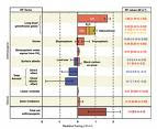
The results of the approximate calculation agent driving global warming and the mechanism (column one), based on radiation effects (Radiative Forcing), in units of Watts / m ^ 2, for anthropogenic sources and other sources, marked in red and positive values of columns two and three means contribution to the warming, while blue is the opposite effect. Source: IPCC Report, 2007.
The picture shows that carbon-dioxide gas is the main contributor glass. From the pre-industrial 280 ppm for a 379 ppm in 2005. This figure exceeds the natural rate of climate change studies from the past (paleoclimatology), where over 650 thousand years is only an increase of 180-300 ppm. Especially in the last decade (1995-2005), recorded an increase of carbon-dioxide concentration of the largest annual (1.9 ppm per year), far greater than atmospheric measurements in 1960, (1.4 ppm per year), although there are variations in per - year.
Source mainly increased concentration of carbon-dioxide is the use of fossil fuels, plus the influence of land surface changes (land clearing, deforestation, forest fires, melting ice). Increasing concentrations of methane (CH4), from 715 ppb (parts per billion = one per billion) in pre-industrial to 1732 ppb in the early 1990s, and 1774 in the year 2005. This exceeds the numbers naturally change over 650 thousand years (from 320 to 790 ppb). The main source of agricultural methane and increased use of fossil fuels. Concentrations of nitrous-oxide (N2O) from 270 ppb - 319 ppb in 2005. Like other contributors to emissions, is the main source of agricultural humans. Combination three main components are the biggest contributor to global warming.
Anthropogenic contribution of aerosols (sulphate, organic carbon, black carbon, nitrate and dust) cooling effect, but the effect is still not dominant compared to the warming, in addition to the uncertainty calculations are still very large. Likewise, the ozone changes due to chemical processes troposper formation of ozone (nitrogen oxides, carbon monoxide and hydrocarbons) contribute to global warming. Ability sunlight reflectivity (Albedo), due to changes in the Earth's surface and the deposition of black carbon aerosol from the snow, resulting in changes varied, from cooling to heating. Changes from sun rays (solar irradiance) is not a big contribution to the warming global.
So, it is understood that humans do play a role for his own fate, because of global warming caused by man's own actions. For that we have responsibility to make some action to save the earth so then human and nature can live in harmony.
October 21, 2009
ASEAN and Global Warming issue

Secretary-General of ASEAN Dr. Surin Pitsuwan, urged the global community to act immediately regarding the issue of climate change in order to save the earth from permanent damage due to global warming.
Referring to the views 'Economics of Climate Change', Surin stressed that the costs of action now would cost just one per cent of world income, while costs to overcome these acts could reach more than 20 percent in the future, he said that the number of human casualties and suffering caused by global warming can not be compensated economically.
Appeal to tackle global warming is conveyed Surin of opportunity "Breakfast Dialogue", which was attended by head of delegation and other senior representatives of ASEAN member countries attending the Climate Change Negotiations September 28 to October 9, 2009 in Bangkok.
"The main message from the G-20 conference recently in Pittsburgh is that the United Nations Framework Convention on Climate Change in Copenhagen in December 2009 to succeed. To this, there must be proof of the progress made in the Discussion of this Bangkok Climate Change," Dr Surin said.
He emphasized, great care and dare express political commitment made by world leaders to find a way out of the negotiations in progress.
Concerns will create results that are fair and equitable can be reached in Copenhagen, with the participation of all countries based on generic principles but have different responsibilities.
At the regional level, ASEAN leaders issued a statement on Climate Change Negotiations in Bali, 2007 and was preparing to issue a joint statement on the upcoming conference in Copenhagen.
Secretary-General further called on ASEAN negotiators to speak with one voice on issues that are common to ASEAN so that regional interests will be protected.
Surin said that while the whole world suffers, ASEAN is the most vulnerable to the impacts of climate change. ASEAN region has a unique natural ecosystems and resources that can provide a source of food for the world and maintaining the global environment.
"We are now more suffering, with storms, floods, earthquakes and other natural disasters. We do not have to make this disaster even worse", he said.
Secretary-General also offered to use his office to promote action on climate change in the long run.
"I will ensure that there is a focal point for greater cooperation on improving cross-sectoral, more specialized studies in specific areas to support targeted actions, and work with our partners from outside the region to form a global partnership in the implementation," he added.
Reference:kompas.com
October 19, 2009
Ice layer at the Arctic Sea

The researchers predicted, the Arctic Sea (poles)of the earth will be free of ice in summer within the next decade. After the spring over, the researchers re-measured the thickness of the ice along the 450 mile route across the Beaufort Sea. They found most of the ice is very thin.
Expedition leader and a sea ice expert from the University of Cambridge, Peter Wadhams, said in the spring of last year's average ice thickness is only 1.8 meters, indicating the age of the layer was about one year. Meanwhile, the ice that had for years about 3 meters.
Thin layer becomes important indications concerning the condition of ice in the Arctic Sea. "Simply put, the thin ice will disappear in an instant ice began to melt season," he said. Wind and ocean currents could also break the thin ice. Broken ice floating freely and be easily driven into the area warmer at the other part of the earth waters and melt. Catlin Arctic Survey and the international conservation group WWF supports these findings.
The situation in the Arctic ice is very influenced climate and natural conditions of the earth. Sea ice conditions in the Arctic is often also associated with climate change and global warming.
Subscribe to:
Posts (Atom)